
Introduction
Mexico is a large country (the world's 13th largest by area) with diverse scenery, ranging from the Sonora desert flanked by the eastern and western Sierra Nevada mountain ranges, a central volcanic belt with towering active volcanoes, the flat limestone Yucatan peninsula, and bordering the Pacific Ocean and the Caribbean. It is a cradle of civilisation, with numerous ancient peoples who were eventually conquered by the Aztecs, then the Spanish, until it achieved independence in the early 19th century, and its struggle for independence continues to be remembered to this day. Today, the United Mexican States is a federal republic comprising 31 states with Mexico City as its capital.
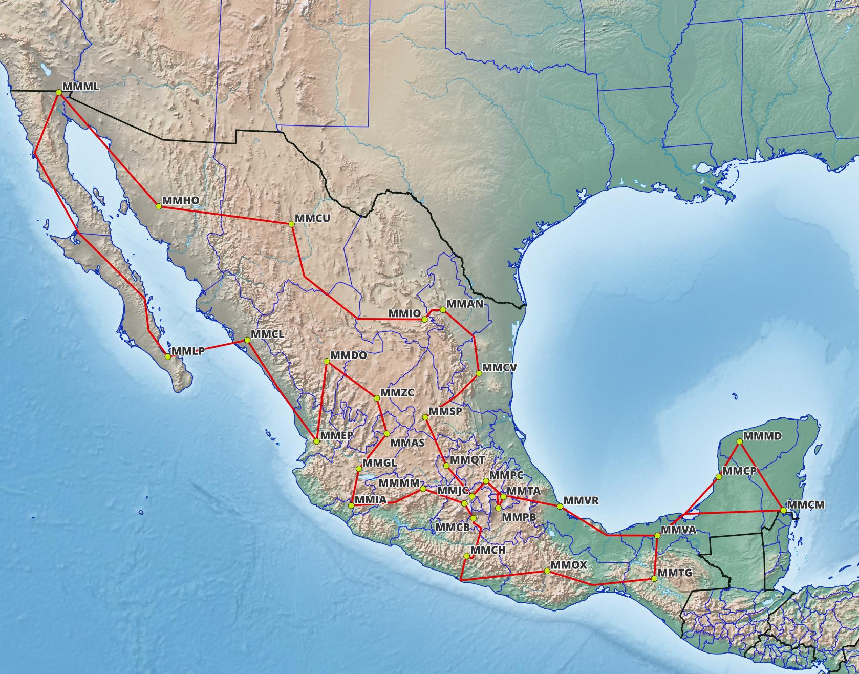
For this tour, our Corporate Services department has been chartered to take a small group around the capitals of the states of Mexico. You may choose any aircraft (though one of our Executive Fleet is recommended) but it is suggested to avoid normally-aspirated piston engined aircraft since they will struggle with some high-elevation airports and mountainous terrain. The route is a circular one, and you can start at any point.
Flight and Planning Tips
Class A airspace is at FL195 and above, and the tour routes are planned to fly on the Victor airways below the Class A floor. RNAV is capability is hardly necessary: most of the Victor airways are between VORs, and there is typically a VOR at each regional or international class airport, with a VOR-based departure procedure from each runway (either a climb on runway heading, make a procedure turn and return to the VOR type, or a DME arc) and an arrival procedure (again, DME arc or procedure turn-based). RNAV procedures routes are published at major international airports to connect with Jet airways. Where there are no suitable SIDs or STARs for Victor airways, it is noted as a non-standard departure/arrival. The Mexico AIP is unfortunately not available free on the Internet, and even old charts may be hard to come by (although they are sometimes packaged with scenery) – a paid service such as Navigraph is essential if you must have up-to-date charts, but failing that, a program like LittleNavmap can help.
ATC, both online and real life, uses Spanish and English. When contacting ATC, it may be advisable to make a short initial call to allow the controller to identify that English is being used and mentally shift gears, rather than launching immediately into a volley of English.
Where multiple airports exist for a city (e.g. Mexico City, Monterrey), a local commuter/GA airport has been chosen rather than a large international one. For an explanation of the route format please refer to the Flight Plan Description page. Suggested altitudes are based on the MEAs of the airways.
The most performance-limiting and challenging airport is Chilpancingo (MMCH), which has no instrument procedures, is at an elevation of 4,199 ft and has a runway of only 4,637 ft length, and is in the middle of a city in a valley surrounded by mountainous terrain. In real life it is served by helicopters and has no scheduled services. Alternatively, Acapulco airport (MMAA) may be used, and our passengers will have to travel to Chilpancingo by road.
Scenery
For FSX/Prepar3D, the default airport runways and aprons can be somewhat out of kilter with the real world. Note that MMTG has been relocated and its position in FSX/P3D corresponds to what is now the Terán air base, not to the current international airport. Particularly for group flying, it is recommended to seek third-party freeware scenery. Since the terrain is somewhat mountainous in some areas, a mesh upgrade will also improve the appearance.
For X-Plane 11 and 12, default scenery is somewhat better, being more up-to-date, but XP11 default scenery can be a little bland, with default stock objects. Modeller @rufio on X-Plane.org in particular has been creating nice detailed freeware Mexican (and Latin American) airports that are framerate-friendly, and PDF airport charts are also provided in the packages.